Louisiana Braces For Barry
 • Hurricane, tropical storm and storm-surge warnings are now in effect for the coast of Louisiana from Intracoastal City to Grand Isle, as Tropical Storm Barry threatens to strengthen into a Category 1 hurricane as it continues its relentless path toward the New Orleans region, bringing with it the chance of major flooding. Late Thursday afternoon, the National Weather Service reports the storm was less than 90 miles south-southeast of the mouth of the Mississippi River and 185 miles southeast of Morgan City, moving west at 5 mph. Maximum sustained winds were 40 mph with higher gusts, but those numbers are expected to strengthen over the next the few days.
Given the fact that this region is no stranger to major storms, local radio stations are already well into their emergency preparations. RAMP spoke with Kevin Cassidy,SVP/Market Manager of Entercom’s New Orleans group, who informed us, “At this point we are preparing for the worst while hoping for it to somehow dissipate prior to landfall. Regardless, with rainfall expectations in the 15-to-20-inch range, we are likely to have a very serious situation on our hands over the weekend.”Murphy added, “Having been through Katrina, Rita and other major storms, this team has a ton of experience in dealing with issues of this magnitude. We have extensive, highly detailed plans, which are already being executed. Our expectation is that we will be in catastrophe mode throughout the weekend and are staffing accordingly.”
Bob Murphy, iHeartMedia’s Region Senior VP Programming tells RAMP, “Both iHeartMedia News-Talk stations — WJBO/Baton Rouge and WRNO/New Orleans — are monitoring the situation closely and will anchor local coverage as needed. For most residents, flash flooding is the bigger concern in both markets, with recent minor rains causing serious street flooding.” He added, “Jeremy Poursine, the PD of WRNO and WJBO is one of the best at managing the information flow and quickly disseminating to listeners. Also, the national iHeartMedia team has mobilized equipment and other needs to make sure stations are well resourced to keep the community connected and informed.”
Calm Before The Storm— Oddly enough, “It was sunshine and blue skies in New Orleans today — much different than what we woke up to on Wednesday,” said Paul Cannell, PD of Cumulus Media’s WZRH (ALT 92.3) and WRKN (NASH Icon 106.1)/New Orleans, fully aware that this respite was only temporary. “Just south of us, Tropical Storm Barry is moving our way. It’s hard to predict where landfall will be at this point, but it could potentially be a Cat 1 hurricane when it happens. Estimates are that landfall will be west of us, sometime late Friday or early Saturday… which is good and bad — good in that we won’t get a direct hit, but bad in that most of the wind and rain will occur on the east side of the hurricane. The tornados and damaging winds are one thing, but we really don’t need that rain (estimated at 10-15 inches, with some areas getting 20+). Our biggest fear is water. As of today, the Mississippi is expected to crest at 19 to 20 feet. Keep your fingers crossed that the levees hold.”
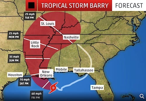
Echoing the sentiments of his fellow broadcasters, Cannell added, “No matter what, we will be here, keeping listeners informed regarding weather conditions, evacuation plans, where to go, and who to call for any kind of assistance.” [Graphic courtesy of The Weather Channel]